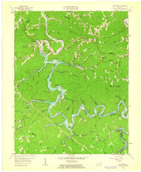
1961 Map of Buckhorn
USGS Topo · Published 1963About this map
The Buckhorn Reservoir dominates this landscape in the early 1960s, its winding waters backfilling the deep valleys of the Kentucky River Middle Fork. This period shows the immediate impact of the newly completed Buckhorn Dam, which transformed the drainage patterns of Breathitt, Perry, and Leslie counties. The map captures the transitional state of the region, where older mountain infrastructure such as Johnson Sch and Schoolhouse Sch sit near modern water management features like a Gaging Station and new Boat Ramps. Local industry is evidenced by scattered Mines and a notable Strip Mine north of Lick Branch. Small communities and family-named hollows like Bowlingtown, Gays, and Confluence are documented alongside natural landmarks such as Buzzard Roost and Langdon Knob, preserving the geography of the hills just as the reservoir altered the traditional river-bottom life.
Find a feature on this map
83 named features on this map. Tap any name to fly to it.
Don’t see what you’re looking for? This feature index may not catch every label — zoom into the map to look around manually.
Map Details
Editions of this 1961 Buckhorn Map
2 editions found
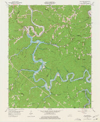
Other maps of this area

1891 · Manchester
USGS Topo · 1:125,000

1891 · Hazard
USGS Topo · 1:125,000

1913 · Buckhorn
USGS Topo · 1:62,500

1916 · Hyden
USGS Topo · 1:48,000

1919 · Hyden
USGS Topo · 1:62,500

1953 · Buckhorn
USGS Topo · 1:24,000

1953 · Cowcreek
USGS Topo · 1:24,000

1953 · Hyden West
USGS Topo · 1:24,000

1953 · Big Creek
USGS Topo · 1:24,000

1953 · Mistletoe
USGS Topo · 1:24,000