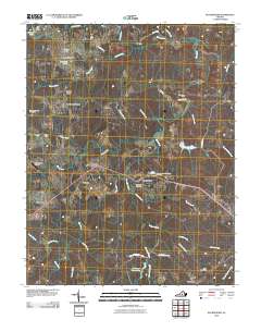
2010 Map of Buckingham
USGS Topo · Published 2010About this map
Buckingham serves as the focal point of this Central Virginia landscape, situated where local roads converge near several community burial grounds including Trinity Cemetery and the Buckingham Community Cemetery. The settlement pattern here is defined by small clusters and family-named locales like Dentons Corner, Alcoma, and the three distinct stages of Old Mount Vinco, Mount Vinco, and New Mount Vinco. To the south, the expansive Appomattox Buckingham SF dominates the terrain, punctuated by the waters of Horsepen Creek Lake. The area's agricultural and industrial heritage is represented by the Slate River Mills located along the winding path of the Slate River. This survey captures the transition between managed forest lands and the rural crossroads that have long anchored this part of the county.
Find a feature on this map
49 named features on this map. Tap any name to fly to it.
Don’t see what you’re looking for? This feature index may not catch every label — zoom into the map to look around manually.
Map Details
Editions of this 2010 Buckingham Map
This is the sole edition of this map. No revisions or reprints were ever made.
Other maps of this area

1891 · Palmyra
USGS Topo · 1:125,000

1891 · Farmville
USGS Topo · 1:125,000

1892 · Buckingham
USGS Topo · 1:125,000

1892 · Appomattox
USGS Topo · 1:125,000

1893 · Farmville
USGS Topo · 1:125,000

1895 · Palmyra
USGS Topo · 1:125,000

1897 · Palmyra
USGS Topo · 1:125,000

1947 · Roanoke
USGS Topo · 1:250,000

1950 · Dillwyn
USGS Topo · 1:62,500

1958 · Farmville
USGS Topo · 1:62,500