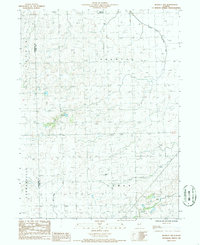
1986 Map of Buckley NW
USGS Topo · Published 1986About this map
The North Fork Vermilion River meanders across the northeast corner of this 1980s landscape, providing a natural drainage point for the surrounding prairie. This area of Ford and Livingston Counties is defined by its extensive agricultural infrastructure and civil divisions, including the rural townships of Brenton, Chatsworth, Germanville, and Lyman. The map details a sophisticated network of drainage efforts essential for Central Illinois farming, most notably the Wall Town Ditch which cuts through the southern sections. Local aviation and rural transport are represented by small, private facilities such as the Bradbury Landing Strip in the north and the Garrells Landing Strip further south. The proximity to local commerce is indicated by the Piper City Corp Bdy shown at the top of the sheet, reflecting the reach of small-town centers into the surrounding countryside.
Find a feature on this map
11 named features on this map. Tap any name to fly to it.
Don’t see what you’re looking for? This feature index may not catch every label — zoom into the map to look around manually.
Map Details
Editions of this 1986 Buckley NW Map
This is the sole edition of this map. No revisions or reprints were ever made.
Other maps of this area

1944 · Piper City
USGS Topo · 1:48,000

1947 · Piper City
USGS Topo · 1:62,500

1947 · Sibley
USGS Topo · 1:62,500

1947 · Cullom
USGS Topo · 1:62,500

1948 · Buckley
USGS Topo · 1:62,500

1949 · Buckley
USGS Topo · 1:62,500

1949 · Cullom
USGS Topo · 1:62,500

1949 · Sibley
USGS Topo · 1:62,500

1958 · Peoria
USGS Topo · 1:250,000

1961 · Peoria
USGS Topo · 1:250,000