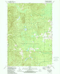
1989 Map of Bucks Pond
USGS Topo · Published 1989About this map
Huron National Forest dominates this northern Michigan landscape, where the township boundaries of Mitchell and Millen meet. The terrain is defined by a dense network of glacial water features, including Bucks Pond, Trout Lake, and Clear Lake, along with specialized wetland environments like Big Marsh, Pennys Marsh, and Mossy Bog. A notable transportation relic is the Old RR Grade in the southeast corner, reflecting the region's historical logging infrastructure. Higher ground is marked by features like Chin Whisker Hill, while the local economy is evidenced by scattered Gravel Pits and a Sandpit. The map also traces established forest routes such as Trask Lake Road and Raymond Road, alongside a dedicated Snowmobile Trail, illustrating the area's transition toward recreational use in the late twentieth century.
Find a feature on this map
26 named features on this map. Tap any name to fly to it.
Don’t see what you’re looking for? This feature index may not catch every label — zoom into the map to look around manually.
Map Details
Editions of this 1989 Bucks Pond Map
This is the sole edition of this map. No revisions or reprints were ever made.
Other maps of this area

1954 · Tawas City
USGS Topo · 1:250,000

1958 · Tawas City
USGS Topo · 1:250,000

1959 · Glennie
USGS Topo · 1:62,500

1972 · Hubbard Lake
USGS Topo · 1:24,000

1972 · Curran
USGS Topo · 1:24,000

1972 · Hubbard Lake SW
USGS Topo · 1:24,000

1972 · Alcona Dam Pond
USGS Topo · 1:24,000
1972 · McGinn Creek
USGS Topo · 1:24,000

1983 · Hubbard Lake
USGS Topo · 1:100,000
1989 · Barton City
USGS Topo · 1:24,000