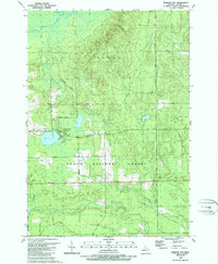
1989 Map of Barton City
USGS Topo · Published 1989About this map
Barton City serves as the central hub of this northern Michigan landscape, positioned near the northern boundary of the Huron National Forest. The settlement is defined by its proximity to Jewell Lake, which features a Boat Ramp and Campground, reflecting the area's role as a destination for outdoor recreation and seasonal residence. Further inland, the map details the rural character of Alcona County through features like Trinity Ch and Maple Ridge Cemetery. The terrain is shaped by a dense network of waterways, including the West Branch Wolf Creek, Vincent Creek, and the West Branch Pine River, which wind through the townships of Hawes, Millen, and Gustin. A notable landmark for the era is the Radio Tower (WBKB) situated along Ritchie Road, while numerous Gravel Pits suggest ongoing local industry within the forested highlands.
Find a feature on this map
29 named features on this map. Tap any name to fly to it.
Don’t see what you’re looking for? This feature index may not catch every label — zoom into the map to look around manually.
Map Details
Editions of this 1989 Barton City Map
This is the sole edition of this map. No revisions or reprints were ever made.
Other maps of this area

1954 · Tawas City
USGS Topo · 1:250,000

1958 · Tawas City
USGS Topo · 1:250,000

1959 · Glennie
USGS Topo · 1:62,500

1959 · Harrisville
USGS Topo · 1:62,500

1971 · Spruce
USGS Topo · 1:24,000

1972 · Hubbard Lake
USGS Topo · 1:24,000

1972 · Hubbard Lake SW
USGS Topo · 1:24,000

1983 · Hubbard Lake
USGS Topo · 1:100,000

1989 · Mikado
USGS Topo · 1:24,000
1989 · Lincoln
USGS Topo · 1:24,000