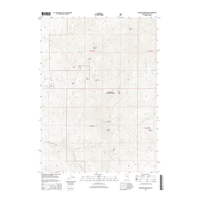
2015 Map of Buckskin Mountain
USGS Topo · Published 2015About this map
The Santa Rosa Range dominates this portion of the Humboldt National Forest, where steep ridgelines and deep drainages define the high desert landscape. At the center of the survey, Buckskin Mtn rises above the dramatic Buckskin Slide, a notable geological feature marking the headwaters of Buckskin Cr. The map reveals a cluster of uniquely named landmarks near the northern boundary, including Auto Hill, Radiator Hill, and Round Hill, suggesting the early influence of motorized travel or specific mining claims in this terrain.
Find a feature on this map
31 named features on this map. Tap any name to fly to it.
Don’t see what you’re looking for? This feature index may not catch every label — zoom into the map to look around manually.
Map Details
Editions of this 2015 Buckskin Mountain Map
This is the sole edition of this map. No revisions or reprints were ever made.
Other maps of this area

1882 · Paradise
USGS Topo · 1:250,000

1893 · Paradise
USGS Topo · 1:250,000

1955 · McDermitt
USGS Topo · 1:250,000

1959 · McDermitt
USGS Topo · 1:250,000

1959 · McDermitt
USGS Topo · 1:62,500

1959 · Hinkey Summit
USGS Topo · 1:62,500

1980 · Odell Mountain
USGS Topo · 1:24,000

1980 · Black Ridge
USGS Topo · 1:24,000
1980 · Holloway Meadows
USGS Topo · 1:24,000

1985 · Quinn River Valley
USGS Topo · 1:100,000