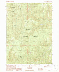
1989 Map of Buckskin Peak
USGS Topo · Published 1989About this map
Buckskin Peak rises at the center of this 1980s landscape, marking a high point in the remote territory along the Josephine and Curry County line. The map captures a wilderness area dominated by the Siskiyou National Forest and the Kalmiopsis Wilderness, where the terrain is defined by a dense network of drainage systems. Water flows through Baldface Creek, Diamond Creek, and Whiskey Creek, eventually reaching the Illinois River in the southeast.
Find a feature on this map
21 named features on this map. Tap any name to fly to it.
Don’t see what you’re looking for? This feature index may not catch every label — zoom into the map to look around manually.
Map Details
Editions of this 1989 Buckskin Peak Map
This is the sole edition of this map. No revisions or reprints were ever made.
Other maps of this area

1917 · Kerby
USGS Topo · 1:125,000

1918 · Kerby
USGS Topo · 1:125,000

1922 · Preston Peak
USGS Topo · 1:125,000

1945 · Kerby
USGS Topo · 1:125,000

1945 · Gasquet
USGS Topo · 1:62,500

1948 · Weed
USGS Topo · 1:250,000

1950 · Weed
USGS Topo · 1:250,000

1951 · Gasquet
USGS Topo · 1:62,500

1954 · Cave Junction
USGS Topo · 1:62,500

1954 · Chetco Peak
USGS Topo · 1:62,500