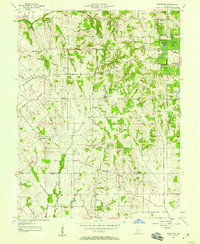
1957 Map of Bucktown
USGS Topo · Published 1958About this map
Greene-Sullivan State Forest dominates the northeastern corner of this 1957 landscape, where industrial activity and conservation began to intersect. The terrain is defined by numerous water bodies including Motorboat Lake, Red Lake, and Twin Lake, which appear alongside expansive Strip Mine operations. This juxtaposition highlights the transition of the land from coal extraction to managed natural space. The Vincennes Tract boundary cuts across the central portion of the map, separating the townships of Haddon, Jefferson, and Widner.
Find a feature on this map
33 named features on this map. Tap any name to fly to it.
Don’t see what you’re looking for? This feature index may not catch every label — zoom into the map to look around manually.
Map Details
Editions of this 1957 Bucktown Map
4 editions found
Other maps of this area

1940 · Linton
USGS Topo · 1:24,000

1943 · Carlisle
USGS Topo · 1:24,000

1943 · Oaktown
USGS Topo · 1:24,000

1943 · Sandborn
USGS Topo · 1:24,000

1943 · Bicknell
USGS Topo · 1:24,000

1943 · Plainville
USGS Topo · 1:24,000

1943 · Sullivan
USGS Topo · 1:24,000

1943 · Dugger
USGS Topo · 1:24,000

1944 · Bucktown
USGS Topo · 1:24,000

1947 · Linton
USGS Topo · 1:24,000