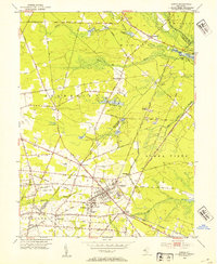
1953 Map of Buena
USGS Topo · Published 1954About this map
Landisville and Minotola form a dense grid of agriculture and industry at the heart of this South Jersey survey, where the Pennsylvania-Reading Seashore Lines intersect the local road network. The landscape is defined by the headwaters of the Hospitality Branch and White Oak Branch, feeding a series of small impoundments like Cedar Lake and Mc Carthys Lakes. Large tracts of land are dedicated to fruit and vegetable farming, a common pattern in this region during the mid-20th century. Local landmarks such as St Michaels Ch, St Marys Cem, and Cleary Sch serve the residential clusters, while the presence of the Downstown Airfield and the Girl Scout Camp reflect the varied land use of the era. To the north, the Black Horse Pike cuts through Monroe and Folsom, connecting these rural outposts to the larger transit corridors of Atlantic and Gloucester counties.
Find a feature on this map
70 named features on this map. Tap any name to fly to it.
Don’t see what you’re looking for? This feature index may not catch every label — zoom into the map to look around manually.
Map Details
Editions of this 1953 Buena Map
4 editions found
Other maps of this area

1890 · Hammonton
USGS Topo · 1:62,500

1890 · Tuckahoe
USGS Topo · 1:62,500

1890 · Bridgeton
USGS Topo · 1:62,500

1890 · Glassboro
USGS Topo · 1:62,500

1893 · Tuckahoe
USGS Topo · 1:62,500

1894 · Hammonton
USGS Topo · 1:62,500

1894 · Bridgeton
USGS Topo · 1:62,500

1898 · Glassboro
USGS Topo · 1:62,500

1898 · Hammonton
USGS Topo · 1:62,500

1899 · Vineland
USGS Topo · 1:125,000
Featured Places
- Vineland, NJ
- Winslow Township, NJ
- Monroe Township, NJ
- Buena Vista Township, NJ
- Buena, Buena Vista Township