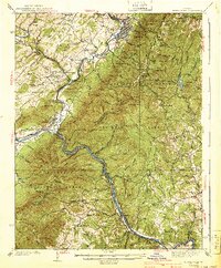
1940 Map of Buena Vista
USGS Topo · Published 1940About this map
The James River carves a deep path through the Blue Ridge Mountains on this 1940 survey, marking the convergence of the George Washington National Forest and the Jefferson National Forest. This river corridor serves as a critical industrial and transport artery, hosting both the Chesapeake and Ohio Railway and the Norfolk and Western Railway. Near the gap at Balcony Falls, the river meets the North Fork, which flows past the industrial site at Buffalo Forge.
Find a feature on this map
106 named features on this map. Tap any name to fly to it.
Don’t see what you’re looking for? This feature index may not catch every label — zoom into the map to look around manually.
Map Details
Editions of this 1940 Buena Vista Map
2 editions found

Other maps of this area

1890 · Roanoke
USGS Topo · 1:125,000

1891 · Roanoke
USGS Topo · 1:125,000

1892 · Lynchburg
USGS Topo · 1:125,000

1894 · Natural Bridge
USGS Topo · 1:125,000

1894 · Lexington
USGS Topo · 1:125,000

1894 · Natural Bridge
USGS Topo · 1:62,500

1907 · Natural Bridge Special
USGS Topo · 1:62,500

1932 · Lexington
USGS Topo · 1:48,000

1935 · Buena Vista
USGS Topo · 1:48,000

1935 · Amherst
USGS Topo · 1:48,000