
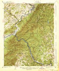
1940 Map of Buena Vista
USGS Topo · Published 1940About this map
Buena Vista and the industrial corridors of the James River dominate this 1940 edition, capturing a landscape defined by the convergence of major mountain railroads. The Chesapeake and Ohio Railway follows the winding river south toward Big Island, while the Norfolk and Western Railway cuts through from the north, meeting at the strategic rail junction of Glasgow. This survey, conducted in the mid-1930s, documents the early footprint of public land management within the George Washington National Forest and Jefferson National Forest, including the location of CCC Camp No 10.
Find a feature on this map
120 named features on this map. Tap any name to fly to it.
Don’t see what you’re looking for? This feature index may not catch every label — zoom into the map to look around manually.
Map Details
Editions of this 1940 Buena Vista Map
2 editions found
Other maps of this area

1890 · Roanoke
USGS Topo · 1:125,000

1891 · Roanoke
USGS Topo · 1:125,000

1892 · Lynchburg
USGS Topo · 1:125,000

1894 · Natural Bridge
USGS Topo · 1:125,000

1894 · Lexington
USGS Topo · 1:125,000

1894 · Natural Bridge
USGS Topo · 1:62,500

1907 · Natural Bridge Special
USGS Topo · 1:62,500

1932 · Lexington
USGS Topo · 1:48,000

1935 · Buena Vista
USGS Topo · 1:48,000

1935 · Amherst
USGS Topo · 1:48,000