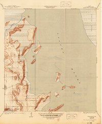
1935 Map of Buena Vista
USGS Topo · Published 1945About this map
Buena Vista Ranch sits at the heart of this coastal Cameron County landscape, reflecting the ranching heritage of South Texas during the early 20th century. Surveyed by W.R. Chenoweth, the map details a complex hydrologic system where the Laguna Madre separates the mainland from the iconic Padre Island. The intricate shoreline is defined by tidal flats and inland water features such as Resaca de los Cuates and Laguna Atascosa, which show water level measurements from 1930. The terrain is marked by distinctive landforms including Horse Island and the cluster known as Three Islands. This survey is particularly notable for its early use of aerial photography to compile culture and drainage patterns, capturing the transition of the Texas Gulf Coast before modern development significantly altered these delicate salt marshes and brushlands.
Find a feature on this map
8 named features on this map. Tap any name to fly to it.
Don’t see what you’re looking for? This feature index may not catch every label — zoom into the map to look around manually.
Map Details
Editions of this 1935 Buena Vista Map
2 editions found
Other maps of this area

1929 · La Coma
USGS Topo · 1:24,000

1929 · Buena Vista
USGS Topo · 1:24,000

1930 · Padre Island No. 1
USGS Topo · 1:24,000

1930 · La Leona
USGS Topo · 1:24,000

1930 · Padre Island No. 2
USGS Topo · 1:24,000

1930 · Laguna Atascosa
USGS Topo · 1:24,000

1934 · La Coma
USGS Topo · 1:31,680

1935 · Padre Island No 1
USGS Topo · 1:31,680

1935 · Padre Island NO. 2
USGS Topo · 1:31,680

1935 · Buena Vista
USGS Topo · 1:31,680