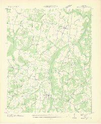
1936 Map of Buena Vista
USGS Topo · Published 1936About this map
The Tennessee Divide splits this landscape in Carroll County, where the Tennessee Valley Authority and USGS documented the rural terrain in the mid-1930s. Centered around Westport and Buena Vista, the area is defined by a dense network of watercourses like the Big Sandy River and Beaver Creek, many of which were managed through engineered features like Buck Ditch and other drainage channels. This period of transition shows a well-established community structure anchored by local institutions such as Williams Chapel, Smyrna Sch, and the Oak Grove Ch. The N C & St L RR provides the primary industrial spine through the region, connecting smaller junctions like Garrettsburg and Dollar. Genealogists will find a wealth of family history in the numerous burial grounds scattered across the ridges, including Cawthon Cem, Mc Callie Cem, and Jamison Cem.
Find a feature on this map
50 named features on this map. Tap any name to fly to it.
Don’t see what you’re looking for? This feature index may not catch every label — zoom into the map to look around manually.
Map Details
Editions of this 1936 Buena Vista Map
2 editions found
Other maps of this area

1936 · Clarksburg
USGS Topo · 1:24,000

1936 · Yuma
USGS Topo · 1:24,000

1936 · Seventeen Creek
USGS Topo · 1:24,000

1936 · Vale
USGS Topo · 1:24,000

1936 · Center Ridge
USGS Topo · 1:24,000

1936 · Bruceton
USGS Topo · 1:24,000

1936 · Cavvia
USGS Topo · 1:24,000

1936 · Buena Vista
USGS Topo · 1:24,000

1950 · Yuma
USGS Topo · 1:24,000

1950 · Palmer Shelter
USGS Topo · 1:24,000