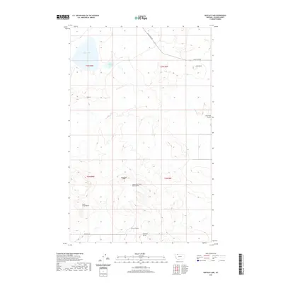
2020 Map of Buffalo Lake
USGS Topo · Published 2020About this map
Buffalo Lake and its smaller neighbor, Little Buffalo Lake, anchor the northern reaches of this high plains landscape in Glacier County. The terrain is defined by a series of distinct elevations and drainage patterns, with Chalk Butte rising in the northeast and Horsethief Ridge marking the central divide. The mapping of Little Rock Coulee and its South Fork illustrates the seasonal watercourses that have carved the earth between prominent landmarks like Little Crown Butte and Antelope Butte. Sparse transportation routes, such as Chalk Butte Rd and Brandvold Rd, trace the section lines of the Public Land Survey System, reflecting the methodical organization of these open western lands.
Find a feature on this map
16 named features on this map. Tap any name to fly to it.
Don’t see what you’re looking for? This feature index may not catch every label — zoom into the map to look around manually.
Map Details
Editions of this 2020 Buffalo Lake Map
This is the sole edition of this map. No revisions or reprints were ever made.
Other maps of this area

1911 · Blackfoot
USGS Topo · 1:125,000

1960 · Cut Bank
USGS Topo · 1:250,000

1963 · Cut Bank
USGS Topo · 1:250,000

1964 · Cut Bank
USGS Topo · 1:250,000

1968 · Buffalo Lake
USGS Topo · 1:24,000

1968 · Rimrock Butte
USGS Topo · 1:24,000
1968 · Love Rock
USGS Topo · 1:24,000

1968 · Rocky Buttes
USGS Topo · 1:24,000
1968 · Fort Piegan
USGS Topo · 1:24,000
1968 · Del Bonita
USGS Topo · 1:24,000