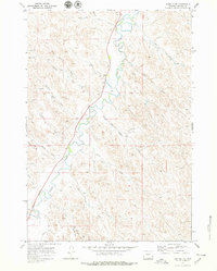
1970 Map of Buffalo NE
USGS Topo · Published 1979About this map
Clear Creek defines this section of Johnson County, winding through a landscape dominated by complex drainage systems and early water management infrastructure. Surveyed in 1970, the map shows how local ranchers and settlers harnessed the water supply through engineering works like the Des Moines Ditch and Redman Ditch. The terrain is deeply etched by numerous family-named draws, including Watt Draw, Lawrence Draw, and Healy Draw, which illustrate the traditional nomenclature of the Wyoming cattle country. While the area is primarily agricultural, signs of resource exploration and utility are evident through a marked Prospect near the northern boundary, a Gravel Pit, and a localized Radio Tower. The sparse road network, centered around Route 16, underscores the rural nature of the high plains before further modern development.
Find a feature on this map
23 named features on this map. Tap any name to fly to it.
Don’t see what you’re looking for? This feature index may not catch every label — zoom into the map to look around manually.
Map Details
Editions of this 1970 Buffalo NE Map
2 editions found
Other maps of this area

1900 · Fort McKinney
USGS Topo · 1:125,000

1903 · Fort McKinney
USGS Topo · 1:125,000

1909 · Sheridan
USGS Topo · 1:125,000

1911 · Sheridan
USGS Topo · 1:125,000

1955 · Sheridan
USGS Topo · 1:250,000

1958 · Sheridan
USGS Topo · 1:250,000

1962 · Sheridan
USGS Topo · 1:250,000
1970 · Buffalo
USGS Topo · 1:24,000

1970 · Buffalo NE
USGS Topo · 1:24,000
1970 · Horse Hill
USGS Topo · 1:24,000