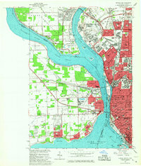
1965 Map of Buffalo NW
USGS Topo · Published 1967About this map
The Niagara River serves as the international boundary and the central axis of this 1960s study, dividing the dense urban landscape of Buffalo and Kenmore from the Canadian shoreline. Along the western bank, the Ontario side features a string of waterfront communities including Fort Erie North, Waverly Beach, and Lakeshore. The river's complexity is illustrated through its various paths, such as the Chippawa Channel and Black Rock Canal, while Grand Island sits at the northern fork with its distinct residential hubs at Grandyle Village and Ferry Village.
Find a feature on this map
98 named features on this map. Tap any name to fly to it.
Don’t see what you’re looking for? This feature index may not catch every label — zoom into the map to look around manually.
Map Details
Editions of this 1965 Buffalo NW Map
2 editions found

Other maps of this area

1894 · Buffalo
USGS Topo · 1:62,500

1894 · Niagara Falls
USGS Topo · 1:62,500

1896 · Niagara Falls
USGS Topo · 1:62,500

1897 · Tonawanda
USGS Topo · 1:62,500

1899 · Niagara
USGS Topo · 1:125,000

1900 · Tonawanda
USGS Topo · 1:62,500

1900 · Niagara Falls
USGS Topo · 1:62,500

1901 · Buffalo
USGS Topo · 1:62,500

1901 · Niagara Falls
USGS Topo · 1:62,500

1901 · Tonawanda
USGS Topo · 1:62,500