
1970 Map of Buffalo NW
USGS Topo · Published 1973About this map
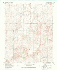
Snake Creek winds through the dissected plains of northern Oklahoma and southern Kansas in this 1970 aerial survey. The map centers on the border between the two states, specifically where Clark Co, Kansas, meets Harper Co, Oklahoma. This is a landscape shaped by agricultural land divisions and the emerging energy economy of the late 20th century. While the settlement of Willard represents the local population center, much of the terrain is marked by township lines for Adams and Wilson. The distribution of Gas Wells and an Oil Well across the southern portion of the quadrangle indicates the industrial footprint in this rural corridor. Near the state line, a small Cem and a Roadside Park offer specific points of interest for genealogists and local historians tracking the development of the region's infrastructure.
Find a feature on this map
11 named features on this map. Tap any name to fly to it.
Don’t see what you’re looking for? This feature index may not catch every label — zoom into the map to look around manually.
Map Details
Editions of this 1970 Buffalo NW Map
2 editions found
Other maps of this area

1894 · Sitka
USGS Topo · 1:62,500

1896 · Ashland
USGS Topo · 1:125,000

1955 · Woodward
USGS Topo · 1:250,000

1955 · Pratt
USGS Topo · 1:250,000

1958 · Woodward
USGS Topo · 1:250,000

1959 · Pratt
USGS Topo · 1:250,000

1970 · Buffalo SE
USGS Topo · 1:24,000

1970 · Rosston NE
USGS Topo · 1:24,000

1970 · Buffalo NE
USGS Topo · 1:24,000

1970 · Buffalo
USGS Topo · 1:24,000