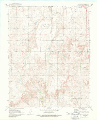
1970 Map of Buffalo NW
USGS Topo · Published 1988About this map
The Oklahoma-Kansas state line defines the northern boundary of this 1970 landscape, where Harper County transitions from rolling prairie into the dissected drainages of Snake Creek and Willow Creek. The small settlement of Willard sits in the northwest, serving as a focal point for local history alongside the nearby Willard Cemetery. This area reflects the mid-century energy economy of the High Plains, with several scattered Oil Well and Gas Well sites dotting the terrain. Near the intersection of modern transit routes, a Roadside Park provides a singular public landmark in an otherwise private ranching and drilling landscape. The map captures the rural infrastructure of the era, from the established sections of Adams and Wilson to the primary path of Route 183.
Find a feature on this map
16 named features on this map. Tap any name to fly to it.
Don’t see what you’re looking for? This feature index may not catch every label — zoom into the map to look around manually.
Map Details
Editions of this 1970 Buffalo NW Map
2 editions found
Other maps of this area

1894 · Sitka
USGS Topo · 1:62,500

1896 · Ashland
USGS Topo · 1:125,000

1955 · Woodward
USGS Topo · 1:250,000

1955 · Pratt
USGS Topo · 1:250,000

1958 · Woodward
USGS Topo · 1:250,000

1959 · Pratt
USGS Topo · 1:250,000

1970 · Buffalo SE
USGS Topo · 1:24,000

1970 · Buffalo NW
USGS Topo · 1:24,000

1970 · Rosston NE
USGS Topo · 1:24,000

1970 · Buffalo NE
USGS Topo · 1:24,000