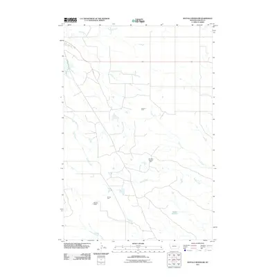
2011 Map of Buffalo Reservoir
USGS Topo · Published 2011About this map
Sandstone Creek and Red Butte Creek carve through this section of eastern Montana, where the ranching landscape of Fallon County is defined by its water management and sparse rail infrastructure. The presence of Kingmont Siding along the northern rail corridor highlights the historical importance of small-scale shipping points for the regional agricultural economy. Water retention is central to the land's utility here, evidenced by the large Buffalo Reservoir and specific engineering projects like the Kirschten Number 1 Dam and Pinnaw Dam. Notable terrain landmarks, such as Bracket Butte, provide vertical contrast to the drainage basins of Corral Creek and Buffalo Creek, illustrating a landscape shaped by intermittent waterflow and managed prairie resources.
Find a feature on this map
10 named features on this map. Tap any name to fly to it.
Don’t see what you’re looking for? This feature index may not catch every label — zoom into the map to look around manually.
Map Details
Editions of this 2011 Buffalo Reservoir Map
This is the sole edition of this map. No revisions or reprints were ever made.
Other maps of this area

1953 · Miles City
USGS Topo · 1:250,000

1957 · Miles City
USGS Topo · 1:250,000

1958 · Miles City
USGS Topo · 1:250,000

1981 · Webster NW
USGS Topo · 1:24,000

1981 · Baker
USGS Topo · 1:100,000

1981 · Baker NE
USGS Topo · 1:24,000

1981 · Buffalo Reservoir
USGS Topo · 1:24,000

1981 · Baker
USGS Topo · 1:24,000

1981 · Willard
USGS Topo · 1:24,000
1981 · Morris Butte
USGS Topo · 1:24,000