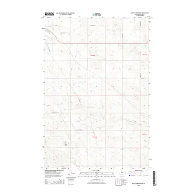
2014 Map of Buffalo Reservoir
USGS Topo · Published 2014About this map
Pennel Oil Field occupies the northwest reaches of this Fallon County landscape, marking the intersection of resource extraction and high-plains agriculture. The terrain is defined by a dendritic network of seasonal waterways including Buffalo Cr, Corral Cr, and Red Butte Cr, which converge near Buffalo Reservoir. This 2014 survey reveals a transition from the industrial activity of the oil field toward the expansive open spaces of the t7n r60e and t7n r61e townships. The local infrastructure supports both ranching and energy interests, with specialized routes such as Sheep Corner Rd, Fertile Prairie Rd, and Landfill Spur Rd branching off from the primary corridor of Us-12. Prominent topographical features like Bracket Butte provide clear landmarks across a region where the names of trails and roads—such as Mink Trl and Water Hole Trl—hint at the area's long history of land use and navigation.
Find a feature on this map
23 named features on this map. Tap any name to fly to it.
Don’t see what you’re looking for? This feature index may not catch every label — zoom into the map to look around manually.
Map Details
Editions of this 2014 Buffalo Reservoir Map
This is the sole edition of this map. No revisions or reprints were ever made.
Other maps of this area

1953 · Miles City
USGS Topo · 1:250,000

1957 · Miles City
USGS Topo · 1:250,000

1958 · Miles City
USGS Topo · 1:250,000

1981 · Webster NW
USGS Topo · 1:24,000

1981 · Baker
USGS Topo · 1:100,000

1981 · Baker NE
USGS Topo · 1:24,000

1981 · Buffalo Reservoir
USGS Topo · 1:24,000

1981 · Baker
USGS Topo · 1:24,000

1981 · Willard
USGS Topo · 1:24,000
1981 · Morris Butte
USGS Topo · 1:24,000