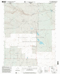
1998 Map of Buffalo Springs
USGS Topo · Published 2001About this map
The high plains along the Oklahoma-Texas border are defined here by the extensive acreage of the Rita Blanca National Grassland. This 1998 revision, based on earlier 1970s topography, illustrates a landscape where water is the primary driver of human presence and land use. Natural features such as the ephemeral Coldwater Creek and the eponymous Buffalo Springs provide critical hydration points in an otherwise arid environment. The map shows a scattered network of wells supporting the ranching and agricultural life of Dallam County. Evidence of local recreation and gathering is centered at Thompson Grove and the Thompson Grove Picnic Area, while the hydrological character of the region is further revealed by the Alkali Lakes and Water Lake. This sheet effectively documents the late 20th-century state of these public lands as they were managed under the Cibola National Forest.
Find a feature on this map
13 named features on this map. Tap any name to fly to it.
Don’t see what you’re looking for? This feature index may not catch every label — zoom into the map to look around manually.
Map Details
Editions of this 1998 Buffalo Springs Map
This is the sole edition of this map. No revisions or reprints were ever made.
Other maps of this area

1954 · Dalhart
USGS Topo · 1:250,000

1958 · Dalhart
USGS Topo · 1:250,000

1962 · Dalhart
USGS Topo · 1:250,000

1969 · Felt SW
USGS Topo · 1:24,000

1969 · Boise City SW
USGS Topo · 1:24,000

1969 · Felt
USGS Topo · 1:24,000

1973 · Buffalo Springs
USGS Topo · 1:24,000

1973 · Tovrea Ranch
USGS Topo · 1:24,000

1973 · Corlena
USGS Topo · 1:24,000

1973 · Perico
USGS Topo · 1:24,000