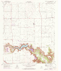
1965 Map of Buffalo Springs Lake
USGS Topo · Published 1976About this map
Buffalo Springs Lake dominates the lower-central portion of this survey, cradled within the steep, branching relief of Yellow House Canyon. This dramatic cut into the Llano Estacado plains provides a sharp contrast to the surrounding grid of farmland and oil infrastructure. Along the Double Mountain Fork Brazos River and its North Fork, the terrain descends rapidly through layered contours, revealing a complex landscape of bluffs and drainage channels that diverge from the flat agricultural tableland above.
Find a feature on this map
22 named features on this map. Tap any name to fly to it.
Don’t see what you’re looking for? This feature index may not catch every label — zoom into the map to look around manually.
Map Details
Editions of this 1965 Buffalo Springs Lake Map
2 editions found
Other maps of this area

1954 · Lubbock
USGS Topo · 1:250,000

1956 · New Deal
USGS Topo · 1:24,000

1957 · Lubbock East
USGS Topo · 1:24,000

1957 · New Home
USGS Topo · 1:62,500

1957 · Lubbock
USGS Topo · 1:62,500

1965 · Acuff
USGS Topo · 1:24,000

1965 · Slaton
USGS Topo · 1:24,000

1965 · Buffalo Springs Lake
USGS Topo · 1:24,000

1965 · Slaton NE
USGS Topo · 1:24,000

1965 · Idalou
USGS Topo · 1:24,000