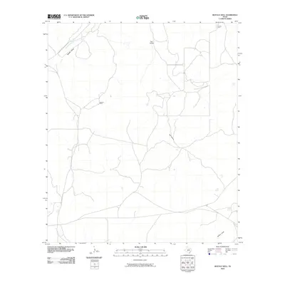
2010 Map of Buffalo Well
USGS Topo · Published 2010About this map
Humble Camp and the Wardlaw Ranch sit within the high plains of Schleicher County, illustrating the sparse but enduring ranching and energy infrastructure of the Edwards Plateau. The landscape is defined by its intermittent drainage systems, notably the Middle Valley Prong and Buffalo Draw, which channel seasonal water through the dry limestone terrain. These topographical features, including the distinctive Bull Hollow, dictate the placement of local roads like Co RD 245. The map provides a precise look at the rural property boundaries and remote work sites that characterize this part of West Texas, where water features often serve as the primary landmarks in an otherwise open range.
Find a feature on this map
7 named features on this map. Tap any name to fly to it.
Don’t see what you’re looking for? This feature index may not catch every label — zoom into the map to look around manually.
Map Details
Editions of this 2010 Buffalo Well Map
This is the sole edition of this map. No revisions or reprints were ever made.
Other maps of this area

1893 · Fort McKavett
USGS Topo · 1:125,000

1954 · Sonora
USGS Topo · 1:250,000

1958 · Sonora
USGS Topo · 1:250,000

1963 · Buffalo Well
USGS Topo · 1:24,000

1963 · Buffalo Well NW
USGS Topo · 1:24,000

1963 · Buffalo Well SE
USGS Topo · 1:24,000

1963 · Adams SE
USGS Topo · 1:24,000
1963 · Brokeleg Mountain
USGS Topo · 1:24,000

1963 · Buffalo Well SW
USGS Topo · 1:24,000

1963 · Adams SW
USGS Topo · 1:24,000