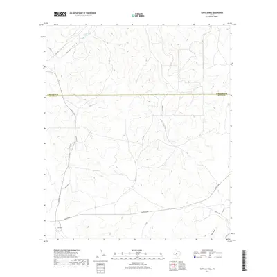
2019 Map of Buffalo Well
USGS Topo · Published 2019About this map
Middle Valley dominates this West Texas landscape along the Schleicher and Sutton County line. The terrain is defined by dry watercourses including the Middle Valley Prong, Bull Hollow, and Buffalo Draw, which carve through the Edwards Plateau region. The settlement at Buffalo Well sits in the southwest corner, serving as a focal point for a network of ranch roads and utility corridors such as Old Pipeline Rd. This 2019 survey illustrates the modern ranching infrastructure of the region, where access is provided by a mix of public routes like Ranch Rd 2596 and Ranch Rd 864 and numerous private tracks like Pvt Rd 2262. The map captures the quiet, expansive nature of these high-plains counties where water sources and named draws dictate the placement of roads and homesteads.
Find a feature on this map
22 named features on this map. Tap any name to fly to it.
Don’t see what you’re looking for? This feature index may not catch every label — zoom into the map to look around manually.
Map Details
Editions of this 2019 Buffalo Well Map
This is the sole edition of this map. No revisions or reprints were ever made.
Other maps of this area

1893 · Fort McKavett
USGS Topo · 1:125,000

1954 · Sonora
USGS Topo · 1:250,000

1958 · Sonora
USGS Topo · 1:250,000

1963 · Buffalo Well
USGS Topo · 1:24,000

1963 · Buffalo Well NW
USGS Topo · 1:24,000

1963 · Buffalo Well SE
USGS Topo · 1:24,000

1963 · Adams SE
USGS Topo · 1:24,000
1963 · Brokeleg Mountain
USGS Topo · 1:24,000

1963 · Buffalo Well SW
USGS Topo · 1:24,000

1963 · Adams SW
USGS Topo · 1:24,000