
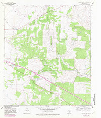
1963 Map of Buffalo Well SW
USGS Topo · Published 1966About this map
Family-named ranching properties define this portion of Sutton County in the early 1960s, reflecting a landscape dominated by livestock and energy production. The North Llano River and North Llano Draw provide the primary drainage through the area, where water remains the critical resource for operations like the Halbert Ranch, Les Allison Ranch, and S Allison Ranch. Scattered Gravel Pit locations and numerous Gas Well sites indicate the intersection of traditional land use with the region's mineral industry. Of particular interest to local historians are the human-scale landmarks of the era, such as the remote Landing Field and the Roadside Park located near the Clarkson Ranch. This survey captures the rural infrastructure of central Texas before significant modern development altered these traditional ranching boundaries.
Find a feature on this map
15 named features on this map. Tap any name to fly to it.
Don’t see what you’re looking for? This feature index may not catch every label — zoom into the map to look around manually.
Map Details
Editions of this 1963 Buffalo Well SW Map
2 editions found
Other maps of this area

1893 · Rock Springs
USGS Topo · 1:125,000

1893 · Fort McKavett
USGS Topo · 1:125,000

1954 · Sonora
USGS Topo · 1:250,000

1958 · Sonora
USGS Topo · 1:250,000

1963 · Steen Lake
USGS Topo · 1:24,000

1963 · Buffalo Well
USGS Topo · 1:24,000

1963 · Live Oak Draw
USGS Topo · 1:24,000

1963 · Buffalo Well NW
USGS Topo · 1:24,000

1963 · Buffalo Well SE
USGS Topo · 1:24,000

1964 · Sonora SE
USGS Topo · 1:24,000