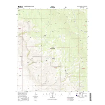
2017 Map of Bug Scuffle Canyon
USGS Topo · Published 2017About this map
The Sacramento Mountains define the high-elevation landscape of this Otero County region, where the residential community of Timberon sits near the southeastern corner. This area serves as a significant intersection of federal and military management, with the Lincoln National Forest covering the northern half of the sheet and the northern reaches of the Fort Bliss military reservation extending into the southwest.
Find a feature on this map
45 named features on this map. Tap any name to fly to it.
Don’t see what you’re looking for? This feature index may not catch every label — zoom into the map to look around manually.
Map Details
Editions of this 2017 Bug Scuffle Canyon Map
This is the sole edition of this map. No revisions or reprints were ever made.
Other maps of this area

1950 · Escondido Canyon
USGS Topo · 1:62,500

1950 · Alamogordo
USGS Topo · 1:62,500

1952 · Cloudcroft
USGS Topo · 1:62,500

1954 · Carlsbad
USGS Topo · 1:250,000

1958 · Carlsbad
USGS Topo · 1:250,000

1965 · Rogers Ruins
USGS Topo · 1:24,000

1965 · El Paso Canyon
USGS Topo · 1:24,000
1974 · Bluff Springs
USGS Topo · 1:24,000

1976 · Mule Peak
USGS Topo · 1:24,000

1979 · Alamogordo
USGS Topo · 1:100,000