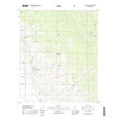
2020 Map of Bug Scuffle Canyon
USGS Topo · Published 2020About this map
Lincoln National Forest dominates this section of Otero County, where high ridges and deep drainages define the southeastern reach of the Sacramento Mountains. The landscape is a network of named canyons and ridges, including the prominent Bug Scuffle Canyon and Moore Ridge. Water management for livestock or wildlife is evident through scattered infrastructure like Turkey Roost Tank and Corner Dry Pasture Tank, alongside natural features such as Dripping Spring and Little Cherry Spring. The southern boundary of the map indicates the northern reaches of the Fort Bliss military reservation, highlighting the transition from protected forest lands to military training grounds. Tracing the path of the Sacramento River and its surrounding canyons like Danley Canyon provides a clear view of the complex topographical relief that characterizes this high-altitude region.
Find a feature on this map
42 named features on this map. Tap any name to fly to it.
Don’t see what you’re looking for? This feature index may not catch every label — zoom into the map to look around manually.
Map Details
Editions of this 2020 Bug Scuffle Canyon Map
This is the sole edition of this map. No revisions or reprints were ever made.
Other maps of this area

1950 · Escondido Canyon
USGS Topo · 1:62,500

1950 · Alamogordo
USGS Topo · 1:62,500

1952 · Cloudcroft
USGS Topo · 1:62,500

1954 · Carlsbad
USGS Topo · 1:250,000

1958 · Carlsbad
USGS Topo · 1:250,000

1965 · Rogers Ruins
USGS Topo · 1:24,000

1965 · El Paso Canyon
USGS Topo · 1:24,000
1974 · Bluff Springs
USGS Topo · 1:24,000

1976 · Mule Peak
USGS Topo · 1:24,000

1979 · Alamogordo
USGS Topo · 1:100,000