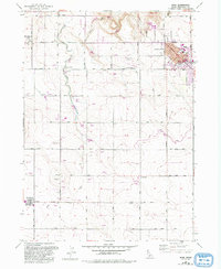
1958 Map of Buhl
USGS Topo · Published 1992About this map
Buhl's grid of streets, including Broadway and Main Ave, anchors this portion of the Snake River Plain during a period of significant agricultural and civic infrastructure development. The landscape is defined by an intricate network of irrigation, including the Low Line Canal and numerous smaller ditches that support a dense concentration of Feedlot and Fish Farm operations along the path of Deep Creek. Civic life is centered around local landmarks like City Hall, the High School, and the Rodeo Grounds, while the presence of the Buhl National Guard Rifle Range and the Idaho National Guard Armory indicates a strong military footprint in the community. Smaller settlements and local landmarks like Fairview, Castleford, and the Grange Hall Farm provide key reference points for researchers studying the mid-century rural development of Twin Falls County.
Find a feature on this map
34 named features on this map. Tap any name to fly to it.
Don’t see what you’re looking for? This feature index may not catch every label — zoom into the map to look around manually.
Map Details
Editions of this 1958 Buhl Map
3 editions found
Other maps of this area

1949 · Thousand Springs
USGS Topo · 1:24,000

1950 · Niagara Springs
USGS Topo · 1:24,000

1950 · Jerome
USGS Topo · 1:62,500

1951 · Thousand Springs
USGS Topo · 1:24,000

1951 · Clover
USGS Topo · 1:24,000

1954 · Thousand Springs
USGS Topo · 1:24,000

1955 · Twin Falls
USGS Topo · 1:250,000

1958 · Twin Falls
USGS Topo · 1:250,000

1958 · Buhl
USGS Topo · 1:24,000

1959 · Buhl
USGS Topo · 1:62,500