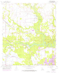
1956 Map of Buhler
USGS Topo · Published 1976About this map
The West Fork Calcasieu River and the Houston River dominate this 1950s landscape, meeting near what is now Sam Houston State Park. This survey, updated with 1970s photorevised data, illustrates a transition from rural timber and wetlands to industrial expansion around Westlake. The Kansas City Southern railroad cuts diagonally through the settlement of Buhler, providing a backbone for the area's transport. Significant local landmarks such as Mt Carmel Ch and the Willow Spring Sch with its adjacent Willow Spring Sch Cem serve as vital markers for genealogists and local historians. The presence of the Indian Bayou Ferry across the main river channel and the Bayou Verdine industrial corridor near the Powerplant and various pumping stations highlights the region's historical reliance on both water-based transit and growing industrial infrastructure.
Find a feature on this map
25 named features on this map. Tap any name to fly to it.
Don’t see what you’re looking for? This feature index may not catch every label — zoom into the map to look around manually.
Map Details
Editions of this 1956 Buhler Map
4 editions found
Other maps of this area

1932 · Lake Charles NW
USGS Topo · 1:31,680

1935 · Buhler
USGS Topo · 1:31,680

1935 · Moss Bluff
USGS Topo · 1:31,680

1935 · Gordon
USGS Topo · 1:31,680

1935 · Gaytine
USGS Topo · 1:31,680

1942 · Lake Charles
USGS Topo · 1:62,500

1947 · Sulphur
USGS Topo · 1:31,680

1947 · Gaytine
USGS Topo · 1:31,680

1947 · Moss Bluff
USGS Topo · 1:31,680

1947 · DeQuincy
USGS Topo · 1:31,680