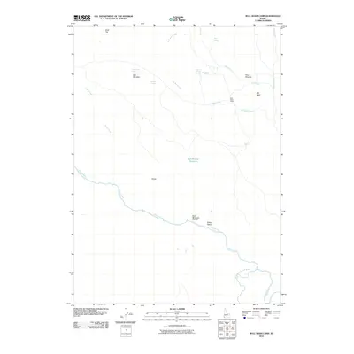
2010 Map of Bull Basin Camp
USGS Topo · Published 2010About this map
Bald Mountain and the canyonlands of the high desert define this remote corner of Owyhee County. The landscape is marked by a network of seasonal water sources and named landmarks vital to ranching and navigation, such as Bull Basin Camp and the small settlement at Dukes. The confluence of the Owyhee River and the South Fork Owyhee River creates a prominent topographical break in the south, while higher elevations feature unique watering points like Head of the Ditch Springs and Snowmaker Spring. Traditional land use is evident in the naming of Wilson Pasture and Cow Meadow, illustrating how the arid terrain was partitioned for grazing. This 2010 survey provides a clear look at the hydraulic infrastructure, including the Bald Mountain Reservoir, within a rugged environment of lava flats and deep river cuts.
Find a feature on this map
22 named features on this map. Tap any name to fly to it.
Don’t see what you’re looking for? This feature index may not catch every label — zoom into the map to look around manually.
Map Details
Editions of this 2010 Bull Basin Camp Map
This is the sole edition of this map. No revisions or reprints were ever made.
Other maps of this area

1955 · Jordan Valley
USGS Topo · 1:250,000

1957 · Jordan Valley
USGS Topo · 1:250,000

1958 · Jordan Valley
USGS Topo · 1:250,000

1973 · Red Basin
USGS Topo · 1:24,000

1973 · Smith Creek
USGS Topo · 1:24,000

1973 · Bedstead Ridge
USGS Topo · 1:24,000

1973 · Grassy Ridge
USGS Topo · 1:24,000

1973 · Spring Creek Basin
USGS Topo · 1:24,000
1977 · Bull Basin Camp
USGS Topo · 1:24,000
1982 · Deacon Crossing
USGS Topo · 1:24,000