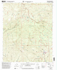
1999 Map of Bull Basin
USGS Topo · Published 2002About this map
The Bull Mountains dominate this high-altitude landscape within the Apache National Forest and Gila National Forest, revealing a remote region defined by high mesas and deep canyons at the turn of the millennium. The land is marked by significant topographical landmarks such as Horse Mesa and Joe Green Peak, with a complex network of seasonal drainages including Dry Leggett Canyon and Saliz Canyon. Evidence of land management and early ranching history is visible through scattered improvements like the Quemado Reserve, Jones Corral, and numerous watering points such as Leggett Cabin Spring and Dave Lee Lake. A small Gravel Pit near the northern boundary and the presence of a Telephone Line and Pipeline underscore the modest industrial footprint in this protected area, which also includes a portion of the Blue Range Wilderness.
Find a feature on this map
72 named features on this map. Tap any name to fly to it.
Don’t see what you’re looking for? This feature index may not catch every label — zoom into the map to look around manually.
Map Details
Editions of this 1999 Bull Basin Map
This is the sole edition of this map. No revisions or reprints were ever made.
Other maps of this area

1915 · Reserve
USGS Topo · 1:125,000

1918 · Reserve
USGS Topo · 1:125,000

1922 · Nutrioso
USGS Topo · 1:125,000

1954 · Clifton
USGS Topo · 1:250,000

1957 · Clifton
USGS Topo · 1:250,000

1958 · Clifton
USGS Topo · 1:250,000

1958 · Alpine
USGS Topo · 1:62,500

1961 · Blue
USGS Topo · 1:62,500

1962 · Clifton
USGS Topo · 1:250,000
1963 · Saliz Pass
USGS Topo · 1:24,000