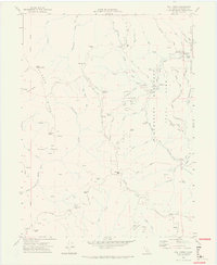
1969 Map of Bull Creek
USGS Topo · Published 1974About this map
Humboldt Redwoods State Park dominates the eastern landscape of this survey, where the Bull Creek watershed meets the Mattole Road. The map documents a rugged timber and ranching area during the late 1960s, featuring remote outposts like Rainbow Ranch and Mann Ranch. Along the creek's winding path, public infrastructure is evident through the Upper Bull Creek Ranger Station, a Gaging Station, and the Bull Creek Cemetery.
Find a feature on this map
59 named features on this map. Tap any name to fly to it.
Don’t see what you’re looking for? This feature index may not catch every label — zoom into the map to look around manually.
Map Details
Editions of this 1969 Bull Creek Map
2 editions found
Other maps of this area

1919 · Glynn
USGS Topo · 1:62,500

1920 · Pt. Delagda
USGS Topo · 1:62,500

1921 · Dyerville
USGS Topo · 1:62,500

1921 · Briceland
USGS Topo · 1:62,500

1949 · Eureka
USGS Topo · 1:250,000

1949 · Point Delgada
USGS Topo · 1:62,500

1949 · Garberville
USGS Topo · 1:62,500

1949 · Weott
USGS Topo · 1:62,500

1950 · Scotia
USGS Topo · 1:62,500

1951 · Scotia
USGS Topo · 1:62,500