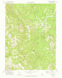
1969 Map of Bull Creek
USGS Topo · Published 1974About this map
Humboldt Redwoods State Park dominates the eastern landscape of this 1969 survey, where the protected groves meet the drainage of Bull Creek. The map documents a rugged terrain defined by significant elevation changes, from peaks like South Rainbow Peak and Thomas Hill down to the winding course of the Mattole River and its Upper North Fork. This era shows a transition in land use, where established holdings like Rainbow Ranch and Mann Ranch sit alongside developing recreation infrastructure, including the Albee Creek Campground and Cuneo Campground. Notable localized details for the historian include the Bull Creek Cem and various remote landings, such as the Landing Strip and Jeep Trail networks that navigate high ridges like Rainbow Ridge and Long Ridge. The presence of a Gaging Station and a Quarry suggests a landscape managed for both its natural resources and its vital water systems.
Find a feature on this map
55 named features on this map. Tap any name to fly to it.
Don’t see what you’re looking for? This feature index may not catch every label — zoom into the map to look around manually.
Map Details
Editions of this 1969 Bull Creek Map
2 editions found
Other maps of this area

1919 · Glynn
USGS Topo · 1:62,500

1920 · Pt. Delagda
USGS Topo · 1:62,500

1921 · Dyerville
USGS Topo · 1:62,500

1921 · Briceland
USGS Topo · 1:62,500

1949 · Eureka
USGS Topo · 1:250,000

1949 · Point Delgada
USGS Topo · 1:62,500

1949 · Garberville
USGS Topo · 1:62,500

1949 · Weott
USGS Topo · 1:62,500

1950 · Scotia
USGS Topo · 1:62,500

1951 · Scotia
USGS Topo · 1:62,500