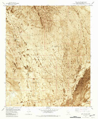
1981 Map of Bull Gap
USGS Topo · Published 1981About this map
White Sands Missile Range dominates this 1981 orthophotomap of Lincoln County, New Mexico, illustrating a stark landscape where military infrastructure meets the volcanic geology of The Malpais. The map utilizes aerial imagery from 1971 and 1972, providing a detailed visual of the arid terrain and volcanic Lava flows. Key operational landmarks such as the Oscura Range Center, an Observation Tower Heliport, and a Radio Tower highlight the region's mid-century role in defense and aerospace testing.
Find a feature on this map
15 named features on this map. Tap any name to fly to it.
Don’t see what you’re looking for? This feature index may not catch every label — zoom into the map to look around manually.
Map Details
Editions of this 1981 Bull Gap Map
2 editions found
Other maps of this area

1916 · Tularosa
USGS Topo · 1:125,000

1918 · Oscura Peak
USGS Topo · 1:125,000

1938 · Carrizozo
USGS Topo · 1:48,000

1943 · Carrizozo
USGS Topo · 1:62,500

1947 · Three Rivers
USGS Topo · 1:62,500

1948 · Chihuahua Ranch
USGS Topo · 1:62,500

1950 · Oscura
USGS Topo · 1:24,000

1950 · Carrizozo
USGS Topo · 1:62,500

1950 · Sierra Blanca Peak
USGS Topo · 1:62,500

1954 · Tularosa
USGS Topo · 1:250,000