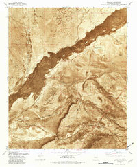
1981 Map of Bull Gap
USGS Topo · Published 1982About this map
The Malpais lava flow dominates this Tularosa Basin landscape, cutting a dark, distinct swath across the high desert terrain. This orthophotomap, based on 1970s aerial photography, reveals a stark intersection of geological force and human infrastructure during the early 1980s. To the west, the boundary of the White Sands Missile Range is clearly marked, while the Southern Pacific tracks and an Old Railroad Grade trace the historical movement of goods and people through this arid corridor. Water sources, vital for ranching and survival, appear as scattered landmarks such as Bull Gap Spring, Dalton Spring, and Craven Well. The rugged geography is defined by Bull Gap Ridge and various canyons, with the Oscura Mine situated near Milagro Hill, reflecting the region's scattered industrial and livestock-raising history.
Find a feature on this map
33 named features on this map. Tap any name to fly to it.
Don’t see what you’re looking for? This feature index may not catch every label — zoom into the map to look around manually.
Map Details
Editions of this 1981 Bull Gap Map
2 editions found
Other maps of this area

1916 · Tularosa
USGS Topo · 1:125,000

1918 · Oscura Peak
USGS Topo · 1:125,000

1938 · Carrizozo
USGS Topo · 1:48,000

1943 · Carrizozo
USGS Topo · 1:62,500

1947 · Three Rivers
USGS Topo · 1:62,500

1948 · Chihuahua Ranch
USGS Topo · 1:62,500

1950 · Oscura
USGS Topo · 1:24,000

1950 · Carrizozo
USGS Topo · 1:62,500

1950 · Sierra Blanca Peak
USGS Topo · 1:62,500

1954 · Tularosa
USGS Topo · 1:250,000