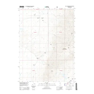
2014 Map of Bull Run Reservoir
USGS Topo · Published 2014About this map
Humboldt National Forest dominates the eastern half of this landscape, where the high terrain of the Bull Run Mountains defines the drainage patterns for the region. The map reveals a land shaped by dramatic elevation changes, from the heights of Porter Peak and Blue Jacket Peak down to the carved depths of Willard Canyon and Echo Canyon. At the southern end, the Bull Run Reservoir serves as a critical water feature, collecting flow from the Bull Run waterway as it emerges through Devils Gap.
Find a feature on this map
34 named features on this map. Tap any name to fly to it.
Don’t see what you’re looking for? This feature index may not catch every label — zoom into the map to look around manually.
Map Details
Editions of this 2014 Bull Run Reservoir Map
This is the sole edition of this map. No revisions or reprints were ever made.
Other maps of this area

1939 · Owyhee
USGS Topo · 1:62,500

1942 · Owyhee
USGS Topo · 1:62,500

1955 · McDermitt
USGS Topo · 1:250,000

1956 · Bull Run
USGS Topo · 1:62,500

1959 · McDermitt
USGS Topo · 1:250,000

1964 · Hat Peak
USGS Topo · 1:62,500

1964 · Wilson Reservoir
USGS Topo · 1:62,500
1970 · Ungina Wongo
USGS Topo · 1:24,000
1971 · Dry Creek Reservoir
USGS Topo · 1:24,000

1982 · Bull Run Mts
USGS Topo · 1:100,000