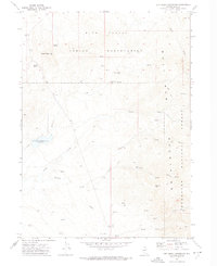
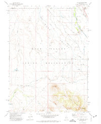
1971 Map of Dry Creek Reservoir
USGS Topo · Published 1974About this map
The high desert landscape of Duck Valley Indian Reservation and the Humboldt National Forest converge in this 1971 topographic study. At the center of the drainage network sits the Dry Creek Reservoir, fed by Dry Creek and Indian Creek. The map documents early water management infrastructure in this arid region, most notably the Homer Ditch which cuts through the southern terrain. Evidence of localized activity is found at the Paisewa Goei settlement and the Petan locale. The eastern boundary is defined by the elevation of the Bull Run Mountains, where natural features like Porcupine Pass and several named water sources such as Granger Spring and Barrel Spring provided critical resources for ranching or travel. Numerous jeep trails crisscross the area, connecting these remote points with landmarks like Crows Nest and White Gate.
Find a feature on this map
27 named features on this map. Tap any name to fly to it.
Don’t see what you’re looking for? This feature index may not catch every label — zoom into the map to look around manually.
Map Details
Editions of this 1971 Dry Creek Reservoir Map
2 editions found
Other maps of this area

1939 · Owyhee
USGS Topo · 1:62,500

1942 · Owyhee
USGS Topo · 1:62,500

1955 · McDermitt
USGS Topo · 1:250,000

1956 · Bull Run
USGS Topo · 1:62,500

1959 · McDermitt
USGS Topo · 1:250,000

1964 · Hat Peak
USGS Topo · 1:62,500

1964 · Wilson Reservoir
USGS Topo · 1:62,500
1970 · Ungina Wongo
USGS Topo · 1:24,000
1971 · Owyhee
USGS Topo · 1:24,000
1971 · The Point
USGS Topo · 1:24,000