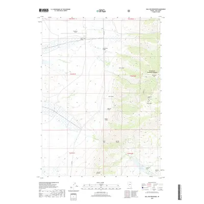
2018 Map of Bull Run Reservoir
USGS Topo · Published 2018About this map
Bull Run Reservoir lies at the southern edge of this high-elevation landscape, where the Bull Run Mountains descend into the Bull Run Basin. The terrain is defined by deep incisions like Echo Canyon, Edgemont Canyon, and Dunn Canyon, which drain the eastern heights of the Humboldt National Forest. High peaks including Blue Jacket Peak and Porter Peak dominate the eastern quadrant, while the northern expanse transitions into the broader Silver Creek Valley.
Find a feature on this map
33 named features on this map. Tap any name to fly to it.
Don’t see what you’re looking for? This feature index may not catch every label — zoom into the map to look around manually.
Map Details
Editions of this 2018 Bull Run Reservoir Map
This is the sole edition of this map. No revisions or reprints were ever made.
Other maps of this area

1939 · Owyhee
USGS Topo · 1:62,500

1942 · Owyhee
USGS Topo · 1:62,500

1955 · McDermitt
USGS Topo · 1:250,000

1956 · Bull Run
USGS Topo · 1:62,500

1959 · McDermitt
USGS Topo · 1:250,000

1964 · Hat Peak
USGS Topo · 1:62,500

1964 · Wilson Reservoir
USGS Topo · 1:62,500
1970 · Ungina Wongo
USGS Topo · 1:24,000
1971 · Dry Creek Reservoir
USGS Topo · 1:24,000

1982 · Bull Run Mts
USGS Topo · 1:100,000