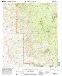
1999 Map of Bullard Peak
USGS Topo · Published 2002About this map
Gila National Forest lands dominate this high-altitude landscape in the late 1990s, centering on the Big Burro Mountains of southwest New Mexico. This region is defined by a dense network of canyons and peaks that historically supported both ranching and mineral extraction. The map reveals the deep-seated mining heritage of the district with several named operations, including the German Mine, the Alhambra Mine, and the Hummingbird Mine, alongside numerous unnamed mine shafts and adits scattered across the terrain. Ranching infrastructure remains prominent, documented through family-named landmarks such as the Bar X Ranch and various corrals like Joe Harris Corral and Peak Corral. Water management is critical in this arid environment, illustrated by an extensive system of tanks and springs, from Little Rough Tank in the north to Richardson Tank and the namesake Bullard Spring near the center of the survey area.
Find a feature on this map
63 named features on this map. Tap any name to fly to it.
Don’t see what you’re looking for? This feature index may not catch every label — zoom into the map to look around manually.
Map Details
Editions of this 1999 Bullard Peak Map
This is the sole edition of this map. No revisions or reprints were ever made.
Other maps of this area

1909 · Silver City
USGS Topo · 1:125,000

1949 · Circle Mesa
USGS Topo · 1:24,000

1950 · Wind Mountain
USGS Topo · 1:24,000

1950 · Burro Peak
USGS Topo · 1:24,000

1951 · Circle Mesa
USGS Topo · 1:24,000

1951 · Big Burro Mountains
USGS Topo · 1:24,000

1951 · Wind Mountain
USGS Topo · 1:24,000

1954 · Silver City
USGS Topo · 1:250,000

1958 · Silver City
USGS Topo · 1:250,000

1959 · Redrock
USGS Topo · 1:62,500