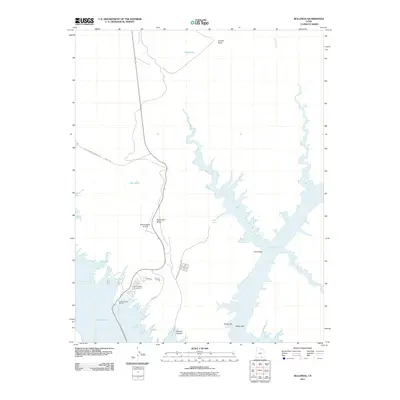
2011 Map of Bullfrog
USGS Topo · Published 2011About this map
Lake Powell dominates this desert landscape within Glen Canyon National Park, where the waters fill a complex network of canyons and ancient bars. The settlement of Bullfrog serves as a primary recreational hub, supported by the Bullfrog Basin Marina, Bullfrog Basin Campground, and the Bullfrog Basin Airport. This 2011 survey captures the vital transportation link provided by the John Atlantic Burr Ferry, which connects travelers across the water from Ferry Rd. Inland from Bullfrog Bay, the topography is defined by high plateaus like Hoskinnini Mesa and the deep drainage of Hansen Creek. The map details the intersection of modern tourism infrastructure with the stark geological features of the Colorado River basin, including named bars such as Moqui Bar and Elbow Bar along the shifting shoreline.
Find a feature on this map
21 named features on this map. Tap any name to fly to it.
Don’t see what you’re looking for? This feature index may not catch every label — zoom into the map to look around manually.
Map Details
Editions of this 2011 Bullfrog Map
This is the sole edition of this map. No revisions or reprints were ever made.
Other maps of this area

1886 · Henry Mountains
USGS Topo · 1:250,000

1892 · Henry Mountains
USGS Topo · 1:250,000

1953 · Mt Pennell 4 NE
USGS Topo · 1:24,000

1953 · The Rincon
USGS Topo · 1:62,500

1953 · Lake Canyon
USGS Topo · 1:62,500

1953 · Mt. Ellsworth
USGS Topo · 1:62,500

1953 · Hall Mesa
USGS Topo · 1:62,500

1956 · Escalante
USGS Topo · 1:250,000

1960 · Escalante
USGS Topo · 1:250,000
1980 · Hite Crossing
USGS Topo · 1:100,000