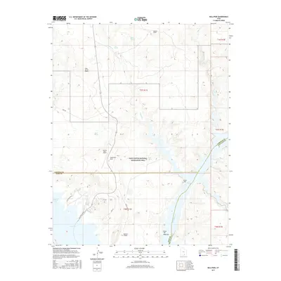
2017 Map of Bullfrog
USGS Topo · Published 2017About this map
Lake Powell and the Colorado River dominate this landscape within the Glen Canyon National Recreation Area, where the desert plateau meets the water. The settlement of Bullfrog serves as a critical hub for recreation and transportation, supported by the Bullfrog Marina and the Bullfrog Basin Airport. The map documents the intricate intersection of land and water, showing how Ferry Rd and Stanton Creek Rd provide access to the shoreline and remote canyons like Stanton Canyon. Prominent landforms such as Hoskinnini Mesa and Danish Knoll rise above the Cane Spring Desert, illustrating the region's geological complexity. This survey illustrates the modern infrastructure built to facilitate access to the river's flooded canyons, including several named bars such as Smith Bar, Elbow Bar, and Moqui Bar along the submerged river channel.
Find a feature on this map
31 named features on this map. Tap any name to fly to it.
Don’t see what you’re looking for? This feature index may not catch every label — zoom into the map to look around manually.
Map Details
Editions of this 2017 Bullfrog Map
This is the sole edition of this map. No revisions or reprints were ever made.
Other maps of this area

1886 · Henry Mountains
USGS Topo · 1:250,000

1892 · Henry Mountains
USGS Topo · 1:250,000

1953 · Mt Pennell 4 NE
USGS Topo · 1:24,000

1953 · The Rincon
USGS Topo · 1:62,500

1953 · Lake Canyon
USGS Topo · 1:62,500

1953 · Mt. Ellsworth
USGS Topo · 1:62,500

1953 · Hall Mesa
USGS Topo · 1:62,500

1956 · Escalante
USGS Topo · 1:250,000

1960 · Escalante
USGS Topo · 1:250,000
1980 · Hite Crossing
USGS Topo · 1:100,000