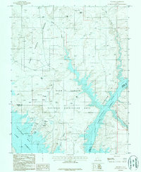
1987 Map of Bullfrog
USGS Topo · Published 1987About this map
Glen Canyon National Recreation Area dominates this mid-1980s landscape, centered on the recreational infrastructure of the Bullfrog settlement. This provisional survey captures the developed waterfront along Bullfrog Bay, featuring a marina, boat ramp, and Bullfrog Campground. The map reveals the logistical footprint required for such a remote destination, including the Bullfrog Basin Airport, a radio facility, and sewage disposal ponds tucked behind the rising terrain of Hoskinnini Mesa.
Find a feature on this map
28 named features on this map. Tap any name to fly to it.
Don’t see what you’re looking for? This feature index may not catch every label — zoom into the map to look around manually.
Map Details
Editions of this 1987 Bullfrog Map
This is the sole edition of this map. No revisions or reprints were ever made.
Other maps of this area

1886 · Henry Mountains
USGS Topo · 1:250,000

1892 · Henry Mountains
USGS Topo · 1:250,000

1953 · Mt Pennell 4 NE
USGS Topo · 1:24,000

1953 · The Rincon
USGS Topo · 1:62,500

1953 · Lake Canyon
USGS Topo · 1:62,500

1953 · Mt. Ellsworth
USGS Topo · 1:62,500

1953 · Hall Mesa
USGS Topo · 1:62,500

1956 · Escalante
USGS Topo · 1:250,000

1960 · Escalante
USGS Topo · 1:250,000
1980 · Hite Crossing
USGS Topo · 1:100,000