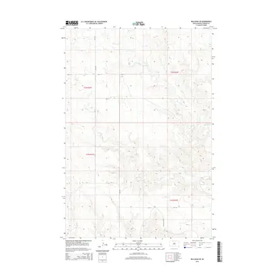
2015 Map of Bullhead SW
USGS Topo · Published 2015About this map
Iron Dog Cr and Stink Cr define the drainage patterns of this rural landscape in the Rock Creek District of South Dakota. The terrain is characterized by the intricate contouring of the prairie, where watercourses have carved subtle valleys through the open plains. The map illustrates a strictly organized section-line road network, including north-south corridors like 245th Ave and 246th Ave, alongside east-west routes such as 107th St. A notable local landmark is the Brown Otter Xing, which sits near the southern boundary. This 2015 survey reflects the enduring grid of the Public Land Survey System, with township and range lines like t22n r24e providing the primary framework for land division in this sparsely populated area of Corson County.
Find a feature on this map
13 named features on this map. Tap any name to fly to it.
Don’t see what you’re looking for? This feature index may not catch every label — zoom into the map to look around manually.
Map Details
Editions of this 2015 Bullhead SW Map
This is the sole edition of this map. No revisions or reprints were ever made.
Other maps of this area

1953 · McIntosh
USGS Topo · 1:250,000

1956 · Black Horse NE
USGS Topo · 1:24,000

1956 · Bullhead
USGS Topo · 1:24,000

1956 · Miscol
USGS Topo · 1:24,000

1956 · Bullhead SW
USGS Topo · 1:24,000

1956 · Miscol NE
USGS Topo · 1:24,000

1958 · McIntosh
USGS Topo · 1:250,000

1972 · Walker
USGS Topo · 1:24,000
1972 · McIntosh SE
USGS Topo · 1:24,000

1972 · McIntosh
USGS Topo · 1:24,000