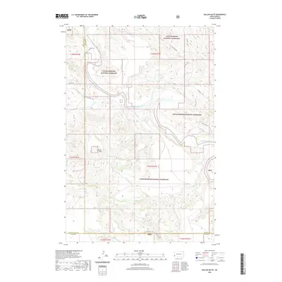
2020 Map of Bullion Butte
USGS Topo · Published 2020About this map
Bullion Butte dominates the central landscape of this western North Dakota quadrangle, serving as a significant topographical landmark within the Little Missouri National Grassland. The Little Missouri River meanders through the northern and eastern reaches of the sheet, carving a complex drainage system that includes Bullion Cr, Dry Bullion Cr, and the seasonal Hanleys Wash. The area's history of ranching and early settlement is anchored by the Connell Cem in the northwest, providing a specific point of interest for genealogists tracing pioneer families in the region. Modern recreational use is reflected in the presence of the Maah Daah Hey trail, which traverses the rugged breaks. Several water sources like Lime Spring and Black Spring are marked, indicating the importance of reliable water in this arid landscape. The map also delineates the meeting point of Golden Valley, Billings, and Slope counties.
Find a feature on this map
28 named features on this map. Tap any name to fly to it.
Don’t see what you’re looking for? This feature index may not catch every label — zoom into the map to look around manually.
Map Details
Editions of this 2020 Bullion Butte Map
This is the sole edition of this map. No revisions or reprints were ever made.
Other maps of this area

1953 · Dickinson
USGS Topo · 1:250,000

1957 · Dickinson
USGS Topo · 1:250,000

1961 · Rocky Ridge
USGS Topo · 1:62,500

1962 · Tracy Mountain
USGS Topo · 1:24,000

1979 · Deep Creek North
USGS Topo · 1:24,000
1979 · Chimney Butte
USGS Topo · 1:24,000

1979 · Square Butte
USGS Topo · 1:24,000

1979 · Bullion Butte
USGS Topo · 1:24,000

1980 · Spring Creek
USGS Topo · 1:24,000

1980 · Belfield
USGS Topo · 1:100,000