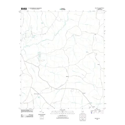
2011 Map of Bullock
USGS Topo · Published 2011About this map
Bullock serves as a central point in this rural landscape within Crenshaw County, situated where Friendship Rd and Pea Creek Rd converge. The terrain is defined by the winding course of the Conecuh River in the northwest and the branching waters of Pea Creek and the West Fork Pea Creek to the south. This area maintains a strong connection to its local heritage through scattered family burial grounds and community landmarks, including the Driskell Family Cemetery and the Antioch Cemetery located along the northern boundary.
Find a feature on this map
62 named features on this map. Tap any name to fly to it.
Don’t see what you’re looking for? This feature index may not catch every label — zoom into the map to look around manually.
Map Details
Editions of this 2011 Bullock Map
This is the sole edition of this map. No revisions or reprints were ever made.
Other maps of this area

1953 · Andalusia
USGS Topo · 1:250,000

1957 · Andalusia
USGS Topo · 1:250,000

1968 · Danleys Crossroads
USGS Topo · 1:24,000
1968 · Goshen
USGS Topo · 1:24,000
1968 · Bluff Springs
USGS Topo · 1:24,000

1968 · Glenwood
USGS Topo · 1:24,000
1968 · Elba
USGS Topo · 1:24,000

1968 · Bullock
USGS Topo · 1:24,000

1971 · Dozier
USGS Topo · 1:24,000

1971 · Luverne
USGS Topo · 1:24,000