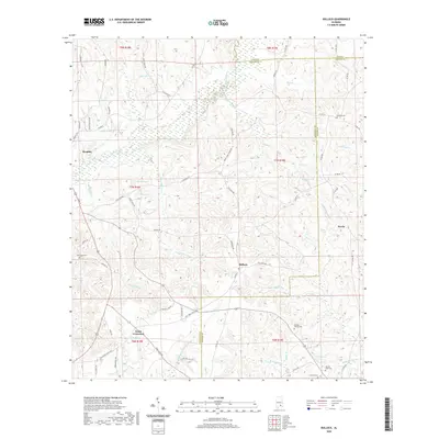
2020 Map of Bullock
USGS Topo · Published 2020About this map
The Conecuh River flows through the western portion of this Alabama landscape, where the town of Brantley serves as a primary hub. The terrain is defined by its intricate drainage networks, with water bodies like Honey Jones Mill Cr and Bryan Mill Cr suggesting a legacy of local milling and early industry. Small rural settlements and intersections such as Bullock, Newby, and Weed Crossroad anchor the interior, connected by a web of local roads including Club Pond Rd and Powell Rd. Genealogy researchers will find significant value in the distribution of family and community burial sites, including the Driskell Family Cem, Antioch Cem, and Oak Grove Cem. The map clearly delineates the tri-county border area where Crenshaw, Pike, and Coffee counties meet, illustrating the persistence of historical property and jurisdictional lines.
Find a feature on this map
82 named features on this map. Tap any name to fly to it.
Don’t see what you’re looking for? This feature index may not catch every label — zoom into the map to look around manually.
Map Details
Editions of this 2020 Bullock Map
This is the sole edition of this map. No revisions or reprints were ever made.
Other maps of this area

1953 · Andalusia
USGS Topo · 1:250,000

1957 · Andalusia
USGS Topo · 1:250,000

1968 · Danleys Crossroads
USGS Topo · 1:24,000
1968 · Goshen
USGS Topo · 1:24,000
1968 · Bluff Springs
USGS Topo · 1:24,000

1968 · Glenwood
USGS Topo · 1:24,000
1968 · Elba
USGS Topo · 1:24,000

1968 · Bullock
USGS Topo · 1:24,000

1971 · Dozier
USGS Topo · 1:24,000

1971 · Luverne
USGS Topo · 1:24,000