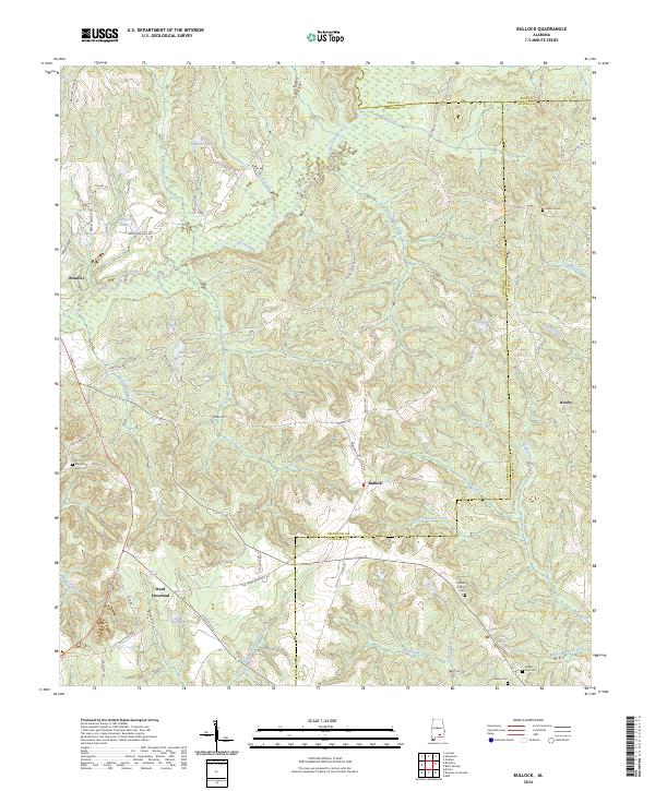
2024 Map of Bullock
USGS Topo · Published 2024About this map
The Conecuh River winds through the northern portion of this landscape, marking the convergence of several major drainages including Bick Creek and Sandy Creek. The terrain is defined by the intersection of Crenshaw, Pike, and Coffee counties, where small agricultural settlements like Bullock and Newby serve as local hubs. This 2024 survey captures a rural network of county roads and family-named landmarks, such as Honey Jones Mill Creek and Bailey Lakes, which suggest a long history of water-powered industry and family landholdings. To the south, the community of Weed Crossroad and the larger town of Brantley anchor the transport network. Local heritage is preserved in numerous burial sites scattered across the landscape, including the Antioch Cem and the Driskell Family Cem, providing essential points of reference for genealogists tracking family lineages in this corner of Alabama.
Find a feature on this map
80 named features on this map. Tap any name to fly to it.
Don’t see what you’re looking for? This feature index may not catch every label — zoom into the map to look around manually.
Map Details
Editions of this 2024 Bullock Map
This is the sole edition of this map. No revisions or reprints were ever made.
Other maps of this area

1953 · Andalusia
USGS Topo · 1:250,000

1957 · Andalusia
USGS Topo · 1:250,000

1968 · Danleys Crossroads
USGS Topo · 1:24,000
1968 · Goshen
USGS Topo · 1:24,000
1968 · Bluff Springs
USGS Topo · 1:24,000

1968 · Glenwood
USGS Topo · 1:24,000
1968 · Elba
USGS Topo · 1:24,000

1968 · Bullock
USGS Topo · 1:24,000

1971 · Dozier
USGS Topo · 1:24,000

1971 · Luverne
USGS Topo · 1:24,000