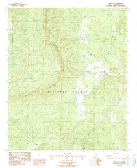
1987 Map of Bulls Gap
USGS Topo · Published 1987About this map
Horn Mountain and Rebecca Mountain dominate this section of the Talladega National Forest along the border of Talladega and Clay counties. The landscape is defined by the winding course of Hatchet Creek, which is joined by numerous tributaries including West Fork, East Fork, and Stillwater Creek. Settlement is sparse, characterized by small communities like Bull Gap and Midway that are connected by unimproved roads through the timbered ridges.
Find a feature on this map
21 named features on this map. Tap any name to fly to it.
Don’t see what you’re looking for? This feature index may not catch every label — zoom into the map to look around manually.
Map Details
Editions of this 1987 Bulls Gap Map
This is the sole edition of this map. No revisions or reprints were ever made.
Other maps of this area

1890 · Talladega
USGS Topo · 1:125,000

1891 · Ashland
USGS Topo · 1:125,000

1892 · Talladega
USGS Topo · 1:125,000

1943 · Talladega
USGS Topo · 1:62,500

1944 · Goodwater
USGS Topo · 1:62,500

1946 · Talladega
USGS Topo · 1:62,500

1947 · Goodwater
USGS Topo · 1:62,500

1953 · Birmingham
USGS Topo · 1:250,000

1953 · Atlanta
USGS Topo · 1:250,000

1956 · Birmingham
USGS Topo · 1:250,000