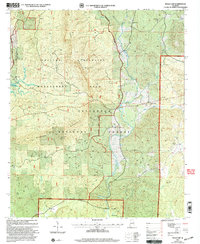
2001 Map of Bulls Gap
USGS Topo · Published 2004About this map
Horn Mountain and Rebecca Mountain dominate this landscape within the Talladega National Forest and the Hollins Wildlife Management Area. This 2001 revision illustrates a rural Alabama landscape characterized by small, scattered settlements and the dense hydrological network of the West Fork Hatchet Creek and East Fork Hatchet Creek. Local community life is anchored by several country churches, such as Bethlehem Ch and Marvin Chapel, which often serve as the primary landmarks for genealogists and local historians. The presence of Glynn Hunter Camp and Hollins Hunter Camp points to the area's continued use for recreation and land management. Further south, the map details small locales like Brownsville and Midway, alongside the waters of Little Hatchet Creek near the Clay County boundary.
Find a feature on this map
23 named features on this map. Tap any name to fly to it.
Don’t see what you’re looking for? This feature index may not catch every label — zoom into the map to look around manually.
Map Details
Editions of this 2001 Bulls Gap Map
This is the sole edition of this map. No revisions or reprints were ever made.
Other maps of this area

1890 · Talladega
USGS Topo · 1:125,000

1891 · Ashland
USGS Topo · 1:125,000

1892 · Talladega
USGS Topo · 1:125,000

1943 · Talladega
USGS Topo · 1:62,500

1944 · Goodwater
USGS Topo · 1:62,500

1946 · Talladega
USGS Topo · 1:62,500

1947 · Goodwater
USGS Topo · 1:62,500

1953 · Birmingham
USGS Topo · 1:250,000

1953 · Atlanta
USGS Topo · 1:250,000

1956 · Birmingham
USGS Topo · 1:250,000