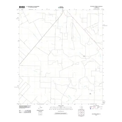
2010 Map of Bullshead Creek
USGS Topo · Published 2010About this map
Bullshead Creek and Papalote Creek define the drainage of this coastal plain landscape in San Patricio County, where the terrain is marked by subtle shifts like Dale Hollow and McFall Draw. The map reveals a highly structured grid of rural roads, including Co RD 511 and FM 888, which support an agricultural economy dependent on the seasonal flow of waterways like Aquilla Creek and Ratta Creek. This 2010 survey reflects a period of established land use, where property boundaries and farm-to-market access are clearly delineated. Genealogists and local historians can trace the network of ranch roads and township connections that link this sparsely settled area to the larger regional hubs. The intersection of many named county roads, such as Co RD 527 and Co RD 520, illustrates the modern infrastructure layered over the historical natural paths and creek crossings.
Find a feature on this map
34 named features on this map. Tap any name to fly to it.
Don’t see what you’re looking for? This feature index may not catch every label — zoom into the map to look around manually.
Map Details
Editions of this 2010 Bullshead Creek Map
This is the sole edition of this map. No revisions or reprints were ever made.
Other maps of this area

1927 · Mathis
USGS Topo · 1:62,500

1953 · Beeville
USGS Topo · 1:250,000

1954 · Skidmore
USGS Topo · 1:62,500

1954 · Fleming
USGS Topo · 1:62,500

1954 · Mathis
USGS Topo · 1:62,500

1954 · Sinton
USGS Topo · 1:62,500

1956 · Beeville
USGS Topo · 1:250,000

1960 · Beeville
USGS Topo · 1:250,000

1979 · Burkes Ridge
USGS Topo · 1:24,000
1979 · Sinton West
USGS Topo · 1:24,000